• LH-MJY1600 15kg Payload 6-Rotor Industrial Drone | 120Min Long Endurance UAV
  • LH-MJY1600 15kg Payload 6-Rotor Industrial Drone | 120Min Long Endurance UAV

LH-MJY1600 15kg Payload 6-Rotor Industrial Drone | 120Min Long Endurance UAV

  • Airframe Structure: 6-rotor, carbon fiber, modular quick-release
  • Load Capacity: Max payload 15kg, max take-off weight 32kg
  • Endurance: 120min no-load, 90min with 5kg payload
  • Flight Performance: Cruise ≥45km/h, max speed ≥54km/h, Level 7 wind resistance
  • Flight Altitude: Takeoff ≥3500m, ceiling ≥6000m (plateau type)
  • Video & Control Link: 2.4GHz integrated link, 15km range (customizable)
  • Protection: IP54 rated, -20℃~70℃, GJB150A-2009 compliant
  • Power System: 8/10 series motors + 60A ESCs, 2×12S 30Ah batteries
  • Airframe Specs: 1613mm wheelbase, 3.45kg weight
  • Navigation: 4-star 8-frequency GNSS, fully autonomous flight

Description

Technical index

两块12S 30Ah
LH-MJY1600-1.6M body technical index
Recommended mount 3kg~15kg
Flight time 3kg~15kg
Body weight 3.45kg
Maximum take-off weight 32kg
Recommended take-off weight 18kg~30kg
Motor/ESC 8 series/10 series/60A
8 series/10 series/60A 27 inch~30 inch
Recommended battery 两块12S 30Ah
Takeoff altitude >0~5000米(高原型
Protection level/ rainproof IP54/light rain
Environmentally adaptive Meet the relevant environmental requirements in GJB150A-2009
LH-MJY1600-1.6M body size parameters
Symmetrical motor wheelbase 1613mm
Inner diameter of motor base 95mm in diameter
Battery compartment size ∅330x105mm(Diameterxheight)
Equipment warehouse size ∅370x35mm(Diameterxheight)
Landing gear height 324mm
Packing box size 95x79x68cm(LengthxWidthxHeight)

Flying platform

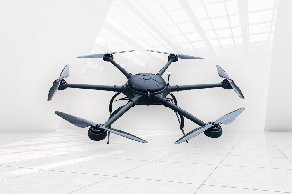
  • Model: LH-MJY1600 body adopts six-axis multi-rotor, plug-in arm configuration;
  • Body material: carbon fiber integrated molding technology;
  • Power system: lithium battery power system;
  • Body size: 1600mm;
  • The maximum total take-off weight is 32kg, the maximum mission load is 15kg, and the standard mission load is 5kg;
  • Vertical take-off and landing capability without manual intervention, landing point offset ≤20cm;
  • No-load endurance time 120min (with CMAN, CAL, LAC-MRA, CNAS and the test report certified by the Ministry of Public Security);
  • Standard mission loading life time is 90min;
  • Cruising speed ≥45km/h, maximum level flight speed ≥54km/h;
  • Wind resistance ≥ Level 7 (with CMAN, CAL, LAC-MRA, CNAS and test reports certified by the Ministry of Public Security);
  • Take-off altitude ≥3500m, level flight ceiling ≥6000m (with CMAN, CAL, LAC-MRA, CNAS and test reports certified by the Ministry of Public Security);
  • Flight attitude stability: pitch angle stability ≤ 4°, roll angle stability ≤ 5°, yaw angle stability ≤ 3°;
  • The image transmission scheme adopts an integrated scheme of image and data, with a frequency of 2.4GHz and a control distance of 15km (standard version, customizable);
  • Flight control deviation: track deviation ≤0.5m, standard deviation ≤0.3m;
  • Hovering control deviation: horizontal deviation ≤ 0.3 m, vertical deviation ≤ 0.3 m;
  • Modular design, with fast assembly and disassembly functions, the assembly and disassembly time is less than 3 minutes (with CMAN, CAL, LAC-MRA, CNAS and the Ministry of Public Security certification test report);
  • The drone supports one-key return to home, supports low battery voltage alarm; supports link interruption to return; supports flight area limitation function;
  • The flight platform has the function of airborne dual GPS to measure the heading angle (with CMAN, CAL, LAC-MRA, CNAS and test reports certified by the Ministry of Public Security);
  • There is a photoelectric pod quick release mechanism in the mission cabin of the flight platform. Facilitate the quick disassembly of the pod before and after the mission;
  • Night navigation capability: with navigation indicator;
  • Carrying capacity: It has the ability to simultaneously carry multiple devices such as dual-optical optoelectronic pods, image transmission, and orthophoto cameras (with CMAN, CAL, LAC-MRA, CNAS and the Ministry of Public Security certified test reports);
  • Scalability: It can be replaced with other sensors such as lidar (with CMAN, CAL, LAC-MRA, CNAS, and inspection reports certified by the Ministry of Public Security);


    Flight control and navigation system

    • Support the whole process and fully autonomous flight;
    • Differential GNSS system supports GPS, GLONASS, Galileo, BDS four-star and eight-frequency signals;
    • With the monitoring function of the ground station, the operation status of the drone can be monitored in real time at the ground station;
    • Emergency response capability: has the function of near-ground avoidance;
    • Temperature compensation, all sensors can perform temperature compensation in the range of -20 degrees to 70 degrees;
    • Sensor integration, with 3-axis accelerometer, 3-axis angular velocity meter, magnetic sensor, dynamic and static pressure sensor;
    • The black box can store 4 hours of detailed flight data at a frequency of 50 Hz;
    • Waypoints, ≥800;
    • Update frequency, ≥200Hz;

    Broadband link

    • Configure dual telemetry remote control links, one of which is disconnected and can be switched to the other link (with CMAN, CAL, LAC-MRA, CNAS and test reports certified by the Ministry of Public Security);
    • The working frequency band meets the relevant requirements of the Ministry of Industry and Information Technology on drone-piloted aircraft systems;
    • Maximum bit rate ≥8Mbps;
    • Transmission video resolution ≥1080P 50fps;
    • Full end-to-end delay of video boundary ≤200ms;
    • Operating distance 15km (standard version, can be customized) (with CMAN, CAL, LAC-MRA, CNAS and the Ministry of Public Security certification test report);
    • RF power ≤2W;
    • 3 communication link

    Ground command station

     The ground command station is a handheld ground operation terminal, integrated with a 7-inch high-definition high-brightness screen, the screen resolution is ≥1080P, and the total weight is 1kg;
    • Operating system: Android;
    • Digital image transmission and remote control: data link, remote control link, and video link are integrated;
    • Built-in battery working time ≥6h, and with external backup battery access function;
    • Support USB projection to computer or display screen;
    • Control radius ≥15 kilometers (standard version, can be customized);
    • Built-in GPS, built-in 4G module;
    • Working temperature: -20℃~60℃;
    • Support one aircraft dual control function, which can realize separate control of aircraft and mount;
    • Pod angle control, zoom, infrared mode, screen switching, image tracking, infrared correction, OSD display, brightness adjustment, contrast adjustment, landing instructions and other functional physical buttons;
    • It supports standard pre-flight inspection, and cannot take off if it fails the self-inspection;
    • Support multiple mission modes such as area scan, path scan, fixed-point gaze, etc., automatically plan and execute the flight plan, improve mission efficiency;
    • Comprehensive display of system status and task status, including: attitude, speed, altitude, position, route status, battery status, link status, photoelectric pod status and other information, image data (infrared images include heat map data) can be stored and exported, The flight log data is complete, can be stored and exported;
    • Support custom video OSD display information content and language;
    • Support route preview function, which can visually display route altitude and terrain altitude difference to avoid mountain collision accidents;
    • Support automatic emergency landing, in case of failure and unable to return to the preset landing point, the nearest preset emergency landing point will be automatically selected for forced landing to ensure safety;
    • Support real-time video output, and input the video of the photoelectric pod to the back-end equipment through the network port;
     
    Leave a message
    Name
    Email*
    Message
    Verification Code*
    Verification Code